, 24.04.2024
Uzbekistan

 BHT-tour


 , 24.04.2024
| Location: | Central Asia |
| Map: | 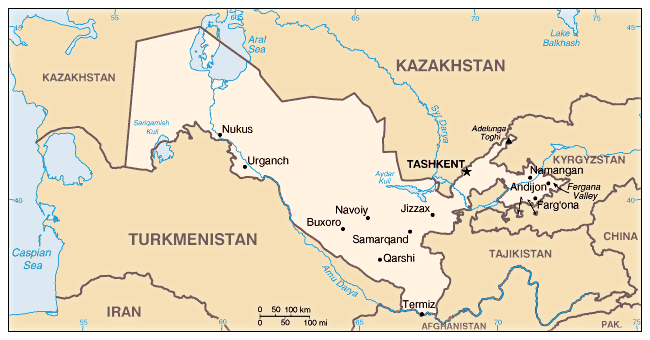 |
| Geographic coordinates: | 41 00 N, 64 00 E |
| Map references: | Asia |
| Area: | total: 447,400 sq km land: 425,400 sq km water: 22,000 sq km |
| Area - comparative: | slightly larger than California |
| Land boundaries: | total: 6,221 km border countries: Afghanistan 137 km, Kazakhstan 2,203 km, Kyrgyzstan 1,099 km, Tajikistan 1,161 km, Turkmenistan 1,621 km |
| Coastline: | 0 km (doubly landlocked); note - Uzbekistan includes the southern portion of the Aral Sea with a 420 km shoreline |
| Climate: | mostly midlatitude desert, long, hot summers, mild winters; semiarid grassland in east |
| Terrain: | mostly flat-to-rolling sandy desert with dunes; broad, flat intensely irrigated river valleys along course of Amu Darya, Syr Darya (Sirdaryo), and Zarafshon; Fergana Valley in east surrounded by mountainous Tajikistan and Kyrgyzstan; shrinking Aral Sea in west |
| Elevation extremes: | lowest point: Sariqarnish Kuli -12 m highest point: Adelunga Toghi 4,301 m |
| Natural resources: | natural gas, petroleum, coal, gold, uranium, silver, copper, lead and zinc, tungsten, molybdenum |
| Land use: | arable land: 10.83% permanent crops: 0.83% other: 88.34% (2001) |
| Irrigated land: | 42,810 sq km (1998 est.) |
| Natural hazards: | NA |
| Geography - note: | along with Liechtenstein, one of the only two do |